


SityTrail - 2745022 - 2021x04x12_19h06m18_gpxxtrace

Ordijamo45
User

Length
9.9 km

Max alt
164 m

Uphill gradient
96 m
Km-Effort
11.2 km

Min alt
118 m

Downhill gradient
101 m
Boucle
Yes
Creation date :
2021-06-01 19:18:16.133
Updated on :
2021-06-01 19:23:43.278
--
Difficulty : Unknown

FREE GPS app for hiking
 SityTrail
IGN / Geographical institutes
SityTrail Plus
The world is yours!
About
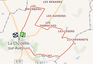
Trail On foot of 9.9 km to be discovered at Centre-Loire Valley, Loiret, La Chapelle-sur-Aveyron. This trail is proposed by Ordijamo45.
Description
Départ du parking de l'étang
Positioning
Country:
France
Region :
Centre-Loire Valley
Department/Province :
Loiret
Municipality :
La Chapelle-sur-Aveyron
Location:
Unknown
Start:(Dec)
Start:(UTM)
489536 ; 5301820 (31T) N.
Comments